Connecting Urbanization to Patterns of Heat and Precipitation Risk: Linking Mechanistic Understanding to Quantification by Remote Sensing
NASA Interdisciplinary Science Program (2020-2023)
Abstract: Urbanization is concentrating our populations and economies in the cross-hairs of hydrometeorological hazards. The mounting evidence of urban impacts on hydrometeorological hazards suggests that urban form impacts the patterns of temperature and precipitation. However, there is currently no protocol for accounting for these shifting probabilities of extremes in urban planning and infrastructure design. This project will build on the observational evidence in the rich history of NASA data sets, but reach beyond the empirical to reveal the causal chain linking urbanization to hydrometeorological risk through controlled numerical experiments with state-of-the-art quantitative models. The overarching goal of this project is to develop a predictive understanding of how critical causative measures of urban form, conditioned on the regional climate context, act to spatially concentrate and organize heat and precipitation risk to urban populations and infrastructure.

Food – Energy – Water Security in the Three Rivers Headwater Region: Integrating science, data, and decision tools to manage under a changing climate and development pressures
Cornell China Center (2019-2022)
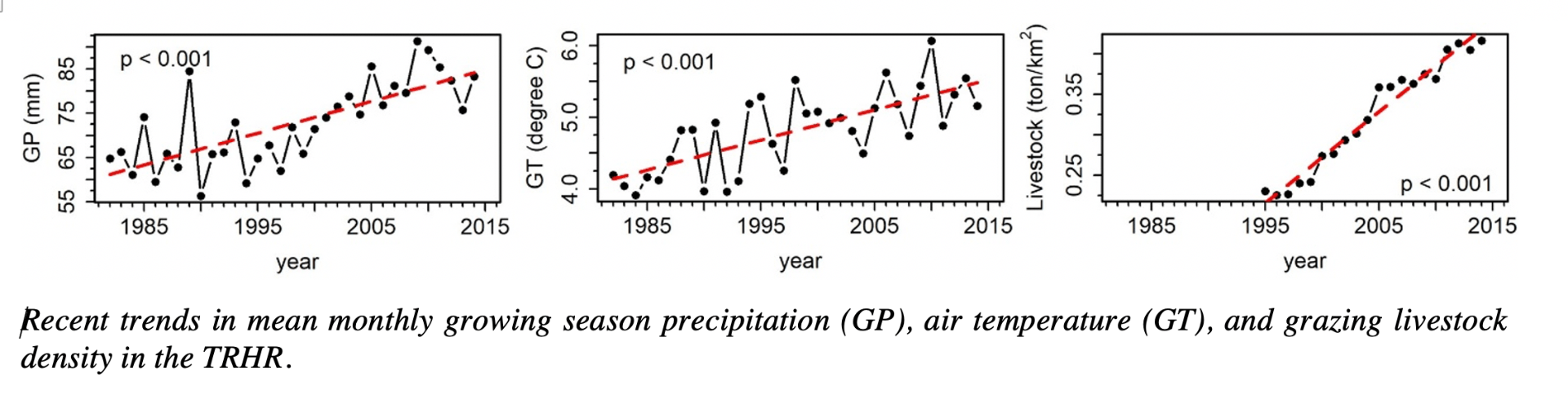
Abstract: The three rivers headwater region of the Tibetan Plateau feeds the Yangtze, Yellow and Mekong rivers, which in turn support the food, energy, and health of large downstream communities. Recent warming has increased upland evaporative demand and put downstream river flows at risk of not meeting demand for hydropower, irrigation, and ecosystem goods and services. This project will quantify the tradeoffs across the competing sectors of hydropower, agriculture, and ecosystem use and develop a sustainable management decision support system. This project has direct contributions toward regional food production and the expansion of renewable energy generation.
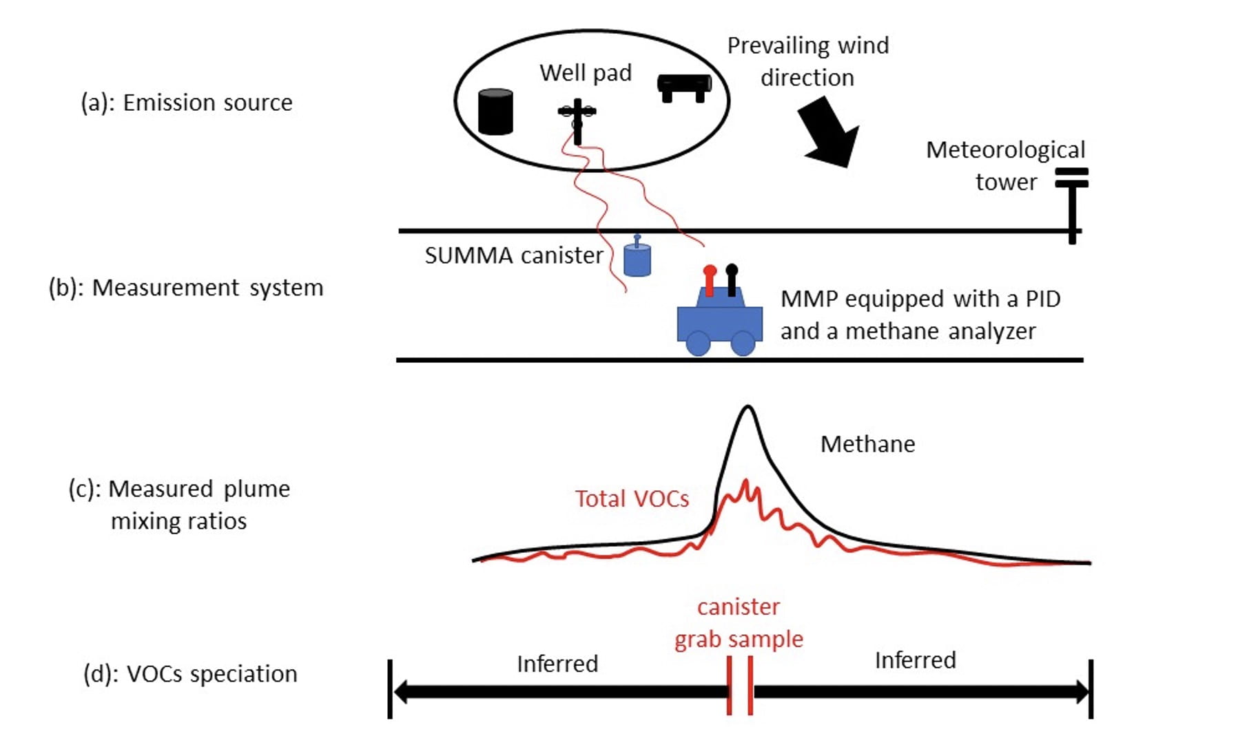
Characterization of VOCs Emissions from Industrial Facilities and Natural Gas Production Sites: A Mobile Sensing Approach
Atkinson Center for a Sustainable Future and EDF
Abstract: With the recent expansion of U.S. oil and gas (O&G) production, many studies have focused on fugitive methane emissions while only a few studies have explored the emissions of volatile organic compounds (VOCs). VOCs are known to affect human health in adjacent communities, both directly through exposure to hazardous pollutants (e.g. benzene, toluene, ethylbenzene, and xylene, or collectively known as BTEX) and indirectly via contribution to the formation of ground-level ozone. In this study, a ground-based mobile measurement system was developed to provide rapid and cost-effective emission surveillance of both methane and VOCs from O&G production sites. After testing in several controlled release experiments, the system was deployed in a field campaign in the Eagle Ford basin, TX. We found a fat-tail distribution for both methane and total VOCs (C4-C12) emissions, such that the top 20% sites ranked according to methane and total VOCs emissions were responsible for~60% and ~80% of total emissions, respectively. A good correlation was found between emission rates of total VOCs and methane (R = 0.74) in the Eagle Ford basin, suggesting that emissions controls may simultaneously help reduce both methane and VOCs in an oil and wet gas basin, such as the Eagle Ford. Little dependence was found between the site-level emission rates and corresponding O&G production rates, suggesting that a considerable portion of emissions may be fugitive. In addition, a strong correlation (R = 0.84) was found between total VOCs emissions estimated using SUMMA canisters taking air samples downwind from individual well pads, and using data reported by an automated gas chromatography (auto-GC) in a regional ambient air monitoring station. This finding suggests that this system has the potential for rapid emission surveillance targeting relatively large emitters, which can help achieve emissions reductions for both greenhouse gas (GHG) and air toxics from O&G production well pads in a cost-effective way.
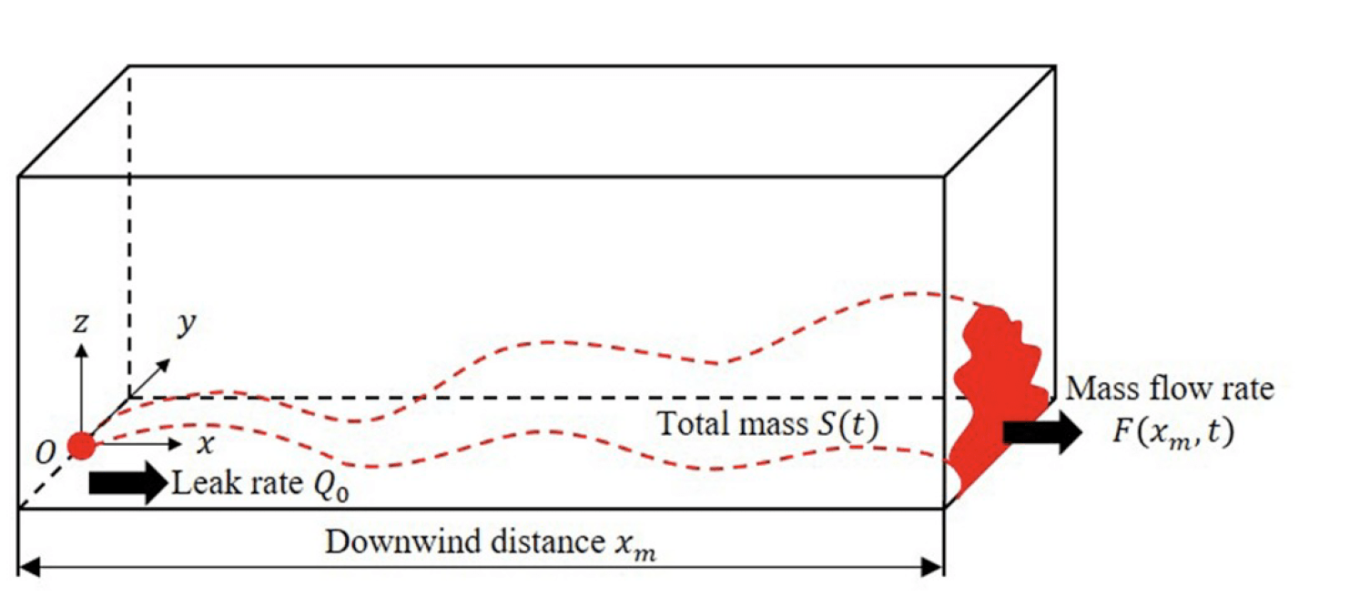
Turbulent Dispersion Tools and Analysis for Identifying Location and Intensity of Fugitive Methane Emissions
ARPA-E MONITOR Program
Abstract: This project involves the development and testing of a set of dispersion algorithms and Bayesian probabilistic inversion tools for localization and estimation of fugitive methane emissions from downwind methane concentration measurements on and near oil and gas well pads.